Ancient Road Publications |
 |
|
Did Israel Cross the Sea of Reeds? By Kyle Pope For years there has been an ongoing debate among Biblical scholars regarding where Israel’s sea crossing during the Egyptian exodus occurred. A recent documentary presented one of the latest theories. It suggested that the Israelietes really crossed through a shallow swamp after the waters had receded prior to a massive tidal wave caused by the eruption of the volcano on the Greek island of Santorini, some 500 miles away. Not only do such fanciful suggestions ignore the claims of Scripture but they betray thinly veiled attempts to explain away the miraculous claims of the Bible. What are the true factors involved in this debate and what clues help us to derive our answers? Geography of the Red Sea What we call the Red Sea today is the western gulf of the Arabian Ocean which flows from the Gulf of Aden at the southernmost tip of Saudi Arabia north to the entrance of the Suez Canal which empties into the Mediterranean. Two branches of the Red Sea divide on either side of the Sinai Peninsula forming the Gulf of Aqaba on the East and the Gulf of Suez on the West. Before the Suez Canal was completed in 1869 the Gulf of Suez branch of the Red Sea stopped some 75-90 miles south of the Mediterranean near the modern city of El Sueis (Suez City). Twenty miles north of it lies the Great Bitter Lake. About 30 miles north of the lake the Nile Delta fans out into various branches which flow into the Mediterranean. Names & Definitions Exodus 15:4 and Deuteronomy 11:4 call the name of the sea that was crossed the Yam Suph. A number of other texts in the Old Testament referring back to this event use the same name (Joshua 2:10; 4:23; 24:6; Nehemiah 9:9; Psalm 106:7, 9, 22; 136:15). The word yam means “sea” (BDB, 410) and the word suph means “reeds” or “rushes” (ibid, 693). Suph is a loanword from the Egyptian word twf meaning “papyrus” (Budge, 2. 853). The Septuagint uses the Greek name thalassa eruthra, meaning literally “Red Sea.” The New Testament uses the same name (Acts 7:36; Hebrews 11:29). Shallow Swamp or Large Sea? Much of the debate stems from the Old Testament name “Sea of Reeds.” Some argue, since papyrus is a fresh water plant this must refer to a fresh water swamp rather than the salt water Gulf of Suez. The problem is that the name is clearly applied to the Red Sea. Exodus 10:19 uses the name in reference to where the Lord destroyed the plague of locusts driven by a strong west wind. We would scarcely imagine that a shallow swamp destroyed every locust in Egypt. In ancient times the term “Red Sea” was applied to the entire Arabian Sea including the Indian Ocean (cf. Strabo, et al.). The Jews appear to have done a similar thing with the term Yam Suph (i.e. “Sea of Reeds.” Solomon built a fleet which he harbored at Ezion Geber, in Edom on the shores of the “Red Sea” (or Gulf of Aqaba - I Kings 9:26). This shows that the name “Sea of Reeds” referred to various gulfs of the Arabian Ocean. The Location of the Crossing 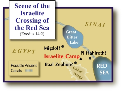 The book of Exodus names
three places in connection with the crossing: Migdol, Pi Hahiroth and Baal
Zephon (Exodus 14:2). According to the text Israel camped between Migdol and
the sea, “before” Pi Hahiroth opposite Baal Zephon (see also Numbers 33:7,8).
Exact identification of the ruins of these sites has yet to come. A migdol was
a fortress, or outpost. This may refer to an outpost on Egypt’s frontier (Erman,
537). Baal-Zephon was the name of “a marine storm-god” who was worshipped throughout
Ancient Canals Long before the Suez Canal was carved the ancients recognized the advantage of a route that provided access between the Mediterranean and the Red Sea. The classical writers Strabo (Geographica, 17.1.25); Aristotle (Meteorologica, 1.15.25-30) and Pliny (Natural History, 6.33.165) all claim that a XII dynasty king named Sesostris began work on a canal connecting the Great Bitter Lake to the Red Sea. Adolf Erman in his text Life in Ancient Egypt cites inscriptional evidence which suggests that such canals were completed in ancient times (p. 537). Erman believed that the Wadi of Tumilat (a dried riverbed that connected the Nile and the Great Bitter Lake) was an ancient canal (p. 27, 28). During the XVIII dynasty the Queen Hatchepsut sent a fleet of five ships down the Red Sea to an African coastal kingdom known as Punt. Ramesses III made a similar journey during the XX dynasty. Some believe that on the return voyages the cargo was brought back through such an ancient canal (Breasted, Budge). The Exodus is believed to have taken place during the XIX dynasty. At the very least this suggests that the name Pi Hahiroth “mouth of the canal” could indicate a site near the mouth of where this ancient canal met the Red Sea. Which Way Did They Go? The straightest route to Canaan would have been north along the Mediterranean Sea, through what is called “The Way of the Philistines.” However, God did not lead them this way so that immediate war with the Philistines would not cause them to turn back to Egypt (Exodus 13:18). Instead they went “The way of the wilderness of the Red Sea” (Exodus 13:19). Something about the lay of the land on this route led Pharaoh to believe that the Israelites were hemmed in. He said to himself, “They are bewildered by the land; the wilderness has closed them in.” (Exodus 14:3). If the Israelites found themselves confronted with canals and the Sea on their left and the 2600 ft. summit of Gebel ‘Ataqa narrowing towards the shore on their right, they would feel as if the wilderness had “closed them in.” It is at this point that God delivers them. The Salvation of the Lord I have no doubt that the eruption of the volcano at Santorini had some effect on Mediterranean geography whenever it occurred. Pumice stones from the island have been found in Egypt. However, those who try to explain the sea crossing through tidal waves or volcanoes fail to carefully consider the claims of the text. Notice three things: 1. A Strong East Wind All That Night. Exodus 14:21 claims that God caused a strong east wind to blow back the waters all that night. A tidal wave from the north would not cause a night long east wind. 2. Dry Ground. No naturalistic explanation could be offered which could cause a seabed which was suddenly exposed to be automatically dry enough for such a multitude of people to cross (Exodus 14:22). 3. The Waters Were a Wall on the Right Hand and on the Left. Water has no shape of its own. It adapts itself to whatever contains it. While a natural wind might blow a wave in one direction it will not cause it to hold its shape. Neither will it cause the water to “wall up” on the right and on the left (Exodus 14:22). This could only come about through a divine miracle that suspended normal laws of nature in order to bring salvation to the children of Israel. |
|
Pope, Kyle. "Did Israel Cross the Sea of Reeds?" Biblical Insights 3.2 (February 2003): 9, 17. |
|
Home Studies Outlines Photos Graphics Fonts Books Tracts Hymns Contact Us |